As usual, this year's canoe trip was another great one. This was our 20th annual trip for the four of us who call ourselves Northstar Expeditions! Actually 20th annual is the average - Jay has completed 21 trips and has never missed a year, Rod and Bryan each have missed one year (hey, I had a daughter born and a thesis to defend), and Rob missed 2 years. Because of the special(?) occasion, we had decided that we needed to extend the trip by a day compared to typical, and to splurge on the flight. The Weaver River is accessible from the road via numerous portages and paddling on some small lakes. It would take about a day to get to Larocque Lake where we got dropped off by airplane, but it's a tough day and reputed to be more portaging than paddling. Our weather for the trip was decent - cool, not cold, occasionally warm and sunny, a bit breezy at times but never too windy, occasionally calm, no real rain to speak of. We had a brief but spectacular show of northern lights one night, and a couple great nights of amazing starry skies. I was happy and comfortable each night in my hammock tent. The other 3 complained of rough ground at times but I never had any issues with that (though the first night my hammock trees were subpar, they were adequate).
On the September long weekend we flew from Missinipe into Larocque Lake and paddled the Weaver River to Hayman Lake, then back to Missinipe after portaging around Sluice Falls. We did the trip over a casual 5 days, including driving from Saskatoon to Missinipe on the first day and flying at 2:30 in the afternoon. That day our paddling was limited to travelling a few km from the landing spot to find a mediocre and exposed campsite toward the NE end of the lake. The portage at the south end of the lake would've been a much nicer spot with room for several tents (and trees suitable for hammock tents).
 |
| Bryan's hammock tent on Larocque Lake. |
 |
| Our Larocque campsite was quite exposed and not a lot of trees. We did have a tarp set up in the evening and overnight. |

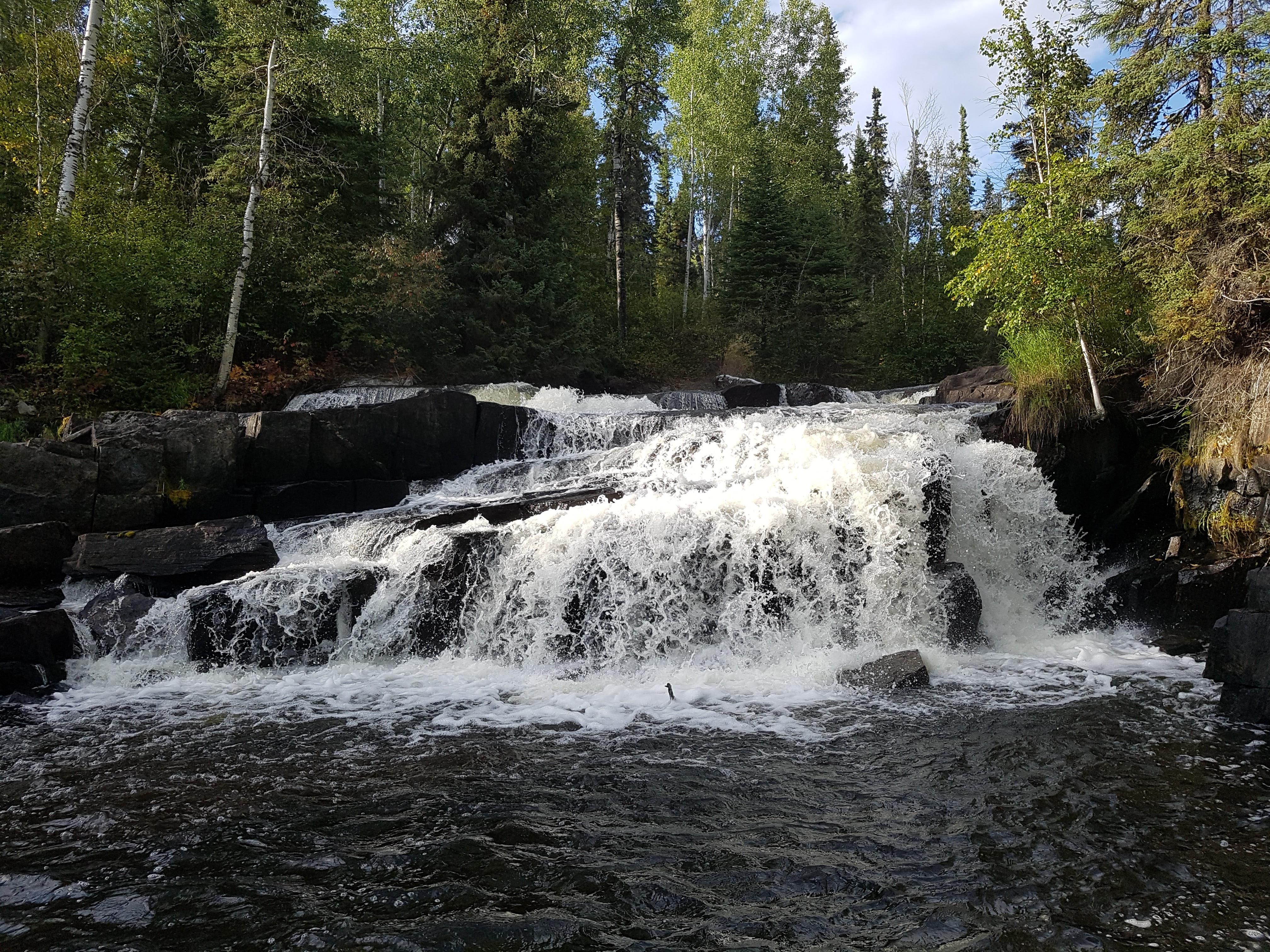
To start the second day, we paddled to the north end of Larocque Lake, viewing the remarkable pictographs along the way. These are the second-most impressive pictographs that I've ever seen (the most impressive ones were between Hickson and Maribelli Lakes, en route to the Paull River). We portaged into Auld Lake to check out the pictographs there as well, then checked out where the Weaver flows via a stony rapid and waterfall into Larocque Lake. Before seeing it, we optimistically thought maybe we could line the canoes or do a short carry over the rocks back down to Larocque but upon getting there we realized that would be either impossible or treacherous, and very much not worth it. There was a little rapid up above the falls a hundred meters or so and I was able to run one canoe through that, then we ferried the other 2 paddlers down the rest of the way to the waterfall. After checking out the falls from above, we headed back to the portage and proceeded back to Larocque Lake and our campsite from the previous night for snacks and to pick up our gear. From there we continued on to Forbes Lake via the short portage.

 |
| Looking toward the drop from Auld Lake to Larocque. This is typical of the Weaver - rocky with a significant drop between lakes. It did get larger in volume by Standunder Falls and Clark Falls, but it's still a pretty small river. |
 |
| Rob must've been telling quite the story... |
 |
| Some of the pictographs on Larocque Lake. |
That second night we camped on Forbes Lake toward it's southern end. The GoTrekkers map merely mentions that "camping opportunities" exist on the islands in the southern portion of Forbes. We didn't see much in the way of "opportunities" at all on Forbes, but did find a fantastic campsite on the SW corner of MacMillan Island. There may be other spots, but that's a good one to keep in mind for sure.
 |
| Meatloaf cooking in the dutch oven. |
 |
| The northern lights were spectacular for a short while, then faded to the background. |


Our third day saw us do a few portages to get onto Bellows Lake and a fantastic spot on the eastern tip of Champagne Island. We avoided one portage by running and lining a rapid where a mining road used to cross the Weaver River. It was pretty tight to get down at the current low flows. In a higher water year it would've been easier, I'm sure. Running that small, shallow, rocky rapids had such a tight turn that Rod and Jay got stuck at the top and had to do a multi-point turn to get around and through, though once through that tight spot they were good all the way down the rest of the rapid. Rob and I managed that first tight turn all right, but then got stuck midway down and turned sideways to the current. That small rapid proved pretty damn powerful and the canoe was at risk of filling up, but we were able to step out and line the rest of the rapid. We spent some time at Standunder Falls where the Weaver flows into Bellows Lake. Only Jay was brave enough stand under Standunder Falls - it was a pretty tight fit and it was damn cold.

 |
| Rob directing Jay and Rod on where to go through this tight rapid. |
 |
| This might've been while they were backing up to get through the tight corner. |
On our fourth day we portaged around Clark Falls and the end of the Weaver River at Hayman Lake on the Churchill River. We completed the 1 km portage around Sluice and camped near bottom of the portage beside Sluice Falls. It's a large site and quite nice though it suffered a big blow down several years ago (after which my buddies and I spent some time and effort clearing the portage and campsite with chainsaws). Once camp was set up in late afternoon it was time to fish since fish was on the menu. It took a while but I caught a nice size walleye and a small one, which together with another two small ones made a nice feast for supper.


Our fifth and last day had us paddle out to Missinipe. Rob and Bryan did the short carry at Ric's Falls to bypass Corner Rapids and Rod and Jay ran Corner. They took some water on and had a pretty good ride and so Rob and I decided not to chance it and did the carry instead. From there we went down the channel to Dieter Rapids and out onto Barker Lake. We checked out the new composting toilet which will hopefully help mitigate the poop impact that this busy area sees. Since it was Tuesday after the long weekend in September, we had the entire area to ourselves. Actually, it wasn't until we left Barker via the 3 Sisters Rapids route and got past Staircase Falls that we saw the first other paddlers of the trip. Those paddlers were on Devil Lake near the launch. On the Weaver itself we'd seen a couple of motorboats with fishermen at Forbes Lake, but otherwise no-one. At Otter Rapids we ran the rapids using the sneak route tight to river left and got down onto Otter Lake mostly without trouble (don't go TOO far left or you might grind to a halt on rocks a few meters from shore). After that it was paddling on Otter Lake toward Osprey Wings in Missinipe. While loading up, Gary Thomson shared many jokes with us then invited us into his office so that we could each select a couple prints of his paintings. With canoes loaded and prints in hand, we drove back home to Saskatoon and were tucked in bed well before midnight.
There are not a lot of resources out there for the Weaver River. The best current resource is the GoTrekkers map produced in conjunction with Churchill River Canoe Outfitters. Be advised that the information on the GoTrekkers maps often has errors (campsites that are fictional, portages that are misplaced). In this case, not all of the marked campsites exist and others are unmarked. Also, in this case they've placed it at about 45° so that NE is up, presumably so that the river fits on less paper. The writing is all still horizontal. The result for me was that my perspective on the map and the land was all skewed and I had to constantly adjust the direction that I thought I was looking or paddling. The scale is 1:40,000 so it's a bit off from what I'm used to in topographic maps. Still, it's the best resource currently available. Find it here: https://www.canoemapscanada.com/products/weaver-river-sk.html
Here are some much better photos that Rob (an actual photographer) posted: https://www.facebook.com/media/set/?vanity=robertkunz&set=a.10208482231570121
Well, would you lookat that, I wasn't going to write a report, I was just going to post a link to some pictures on facebook, but there we are, a report seems to have happened.