Showing posts with label Trip Planning. Show all posts

Wednesday, September 22, 2021

Toporama

I keep forgetting where to find this, so I might as well make a blog post so that you and I can both find it.

The Government of Canada's Toporama mapping site is a handy resource for trip planning. It lets you view the topographic maps for anywhere in Canada. https://atlas.gc.ca/toporama/en/index.html

This link should take you right to the Weaver River, for example: Weaver River Map (Forbes Lake to Weaver Lake section)

You can select and print off your map areas, which is nice. There are also measurement tools. 


a

Tuesday, September 2, 2014

How to Survive after a Paddling Accident

This has also been posted on Bryan's other blog at http://pawistik.blogspot.ca/

Last week while packing for the annual NSE canoe trip I was contacted by Global Saskatoon to comment on how to survive after a mishap on a paddling trip. In addition to being a paddling instructor, I am the Paddle Canada representative for Saskatchewan, and am a co-author of the AdventureSmart paddling safety awareness program called PaddleSmart.

The interview follows on the recent tragic death of David Dice along the Churchill River, a section that NSE paddled in 2010. I do not know the details of what happened, but according to news reports David was found below Needle Falls on Kinosaskaw Lake. Shortly after David was found by fishermen, his wife Enid Dice was found upriver somewhere along Needle Rapids. She had been there without supplies for 8 days. The reports don't offer much for details, though they do mention she had a fire going (it will make your life easier to have some reliable means of starting a fire on your life jacket or in a pocket, and redundancy is good!). The Dices are very experienced outdoorspeople and paddlers, and David's early death is a loss to the paddling community. My condolences go out to all of those grieving David's death.

http://globalnews.ca/video/1533357/surviving-eight-days-in-the-wilderness


A few more details were reported via CBC: http://www.cbc.ca/news/canada/saskatchewan/details-emerge-on-sask-couple-s-tragic-canoe-adventure-1.2750011
One of the first people to speak to Enid after the ordeal was Ric Driediger, owner of Churchill River Canoe Outfitters, who was also one of the last people to see the couple before they set out on their trip.
He says he learned, from Enid, that the couple's canoe capsized as they were navigating a set of rapids on the lake known as Needle Falls*.
They were separated and Enid swam to shore with her husband's backpack that had a sleeping bag and an emergency fire-starting kit. There was no food, however.
*I wonder if this statement as reported is correct. It seems more likely that they were running Needle Rapids (C2+ to C3), about 2.25 km above the falls, or the outlet from Sandfly lake (C3), a further 1 km above Needle Rapids. It seems unlikely that they would have been running the falls (C5), but the earlier sets of rapids are manageable for the canoeist with skills in rapids. This also makes sense since Enid had no gear other than what she swam to shore with and was separated from her husband who was reportedly found on Kinosaskaw Lake in the eddy below the falls. Were the capsize to actually have occurred at the falls, she would have been mere meters from her late husband, the overturned canoe and much of the gear including the SPOT. 

A map of the region:

Open this map full screen.

Aerial view of the rapids at the outlet of Sandfly Lake. We portaged these.

Class 3 rapids at the outlet of Sandfly Lake.

Uppermost portion of Needle Rapids from the spot where we scouted the set. This is the river left channel. 

Jay & Rod scouting Needle Rapids. 


David & Enid's Blog: David and Enid's Travels


Here are some items you should consider having with you, or on you, whenever you head out paddling. Most of these items can be fit into a small pouch that can be attached to the life jacket or contained in a pocket. These items are described as "The Essentials Plus" in the PaddleSmart program:
  • Transport Canada Required Items:
    1. Life jacket
    2. Whistle
    3. Throw bag
    4. Bailer
    5. Waterproof flashlight
  • Other Essential Items:
    1. Fire making kit
    2. Signalling device (e.g. whistle, signal mirror)
    3. Extra food and water
    4. Extra clothing
    5. Navigation & communication devices
    6. First aid
    7. Emergency blanket or shelter
    8. Knife
    9. Sun protection
In the pocket of my PFD I have a small pouch that in the video linked above has had the contents spread out. The contents include a signal mirror, granola bar, fishing line, snare wire, ~20' of thin cord, orange bandana, emergency blanket, lighter, & fire starter. In the canoe or kayak I also almost always have extra clothing, rain gear, some form of shelter (tarp &/or a bothy bag), extra food, water (though we can usually drink our water from the lake), first aid kit, more lighters, matches and fire starting stuff. 

Tuesday, August 26, 2014

Beef Jerky

Time is running out before our 2014 NSE trip (this year it's Surf City on the Churchill River near Missinipe, SK) and I still have to pack and get everything ready. On my "To-Do" list is smoking & drying the jerky for our trip. On Sunday I bought 2 round roasts (5 lbs of meat in total?), sliced them up and marinated them in a homemade teryaki sauce with jerky cure. This evening (Tuesday) they will go into the smoker using this smoke schedule from the Bradley Smoker website:

  1. Dry at 140°F without smoke until the meat is dry (~ 1 hour)
  2. Smoke at 160°F for 2-3 hours
  3. Dry at 175°F until done - about 3 hours.
The sauce I used was gleaned and modified from a couple of different websites and spiced up some, but basically went something like this:
  • 1 cup of soy sauce
  • 1/4 cup white wine (since I didn't have any rice wine or whatever was called for)
  • a couple tablespoons of fresh ginger
  • a fair bit of honey to sweeten the mixture to taste - maybe 1/4 cup or more
  • minced garlic
  • onion powder
  • cayenne
  • ground pepper
  • chili flakes
The sauce was heated to dissolve the honey, then cooled in the freezer before use. Just prior to marinating the meat with the sauce, I added an appropriate amount of cure based on the instructions (just shy of 2 tsp).

Rather than finish in the smoker, I pulled the jerky out after smoking and finished in the dehydrator. The smoker doesn't offer very even heat, getting hot along the back above the burner (some folks install a small fan which would be great in this application). Because the meat is thin it is prone to quickly overcooking in some areas along the back and I would have to counter this by frequently rotating the racks and meat. Since it was late (~11 pm), I decided to finish the drying process on the dehydrator, set to 160°F. I connected the dehydrator to a block heater timer so that it would dry for about 3 hours, be off for the rest of the night, then start up again in the morning to finish it off. I find that second drying step is helpful with a lot of foods - the moisture becomes "trapped" inside the dried outer parts, and takes a very long time to dry properly. By giving the food a bit of a break, the moisture moves outward and becomes more even through the product. Then, a short period of drying (~1 hour in this case) finishes off the product and ensures it is sufficiently dry all the way through.

Smoker set up and ready to go.

5 racks of jerky ready to start the drying step.
The finished product the next morning.

Thursday, August 8, 2013

Where to Go, 2013 Edition

We have 4 days, plus driving up the previous evening. Here are some options I've got rolling around in my brain and that I've been discussing with the group:
  • Option 1.1Upper Sturgeon-Weir River, from Pelican Narrows to Pawistik Lodge on the Hanson Lake Road (Hwy 106). Not very long (50 km), 3 portages around small falls and rapids, sections of swift water. Simple shuttle can probably be arranged via Pawistik Lodge or another area outfitter. I expect typical shield scenery. 
    • Option 1.2: Adding another 50 km to the above, paddling from Jan Lake Lodge to Pelican Narrows. Big water, lots of islands. 
  • Option 2Lower Sturgeon-Weir, from Denare Beach on Amisk Lake to Sturgeon Landing. Paddling off the shield on the lake onto limestone benches of the river with lots of fossils. Starting at Denare Beach, this is 30km of mostly open lake followed by 38 km of river. River is many small rapids with 2 larger rapids that can be portaged if needed. 
  • Option 3McLennan Lake area. Fish, new area. 
  • Option 4Surf City, Corner Rapids. Need I say more?
  • Option 5: Montreal River, Montreal Lake to Hwy 165 Bridge, 66 km. Continuing to Air Ronge brings total distance to 146 km.  Current flows are over 60 cubic m/s; we would want that to drop some, maybe to about 40. Considering this is a spring river, this could be a once-in-a-lifetime chance to run it in September. Never mind that it's been runnable in the fall probably 4 of the last 5 years. 
  • Option 6: Lac LaRonge by kayak. I need more big water kayak camping experience before I go for my Level 3 certification. LaRonge past Nut Point, Wadin Bay, Jay's uncle's cabin or just explore the islands. Head to Hunter Bay. 
Bryan's favourites, in order:
  1. Option 2 Lower S-W
  2. Option 5 Montreal R.
  3. Option 1.1 or 1.2
  4. Option 6 Lac La Ronge
  5. Option 4 Corner Rapids
  6. Option 5 McLennan Lake

Tuesday, April 23, 2013

Northern Saskatchewan "Highway" Shuttle Service

Wherever we end up going for our 2013 trip, it looks like we can rely on Churchill River Canoe Outfitters to pick us up!

Thursday, January 31, 2013

Dreaming of Summer

It's -36°C outside (colder with the windchill considered) and time to dream of summer paddling. While sorting photos on my computer I came across this photo that Rod took on our trip in 2007. It's an awesome reminder of warmer season paddling.

Corner Rapids, Churchill River, SK. Rod Smith photo.
So, with those warm paddling thoughts in mind where should NSE head in 2013? Three of us are turning 40 this year so I think it would be a great year to take a couple extra days and do something more ambitious. I think I'm going to lobby for a fly-in trip on the Paull River (see here for the route description [trip 36] and here for a map) or maybe the Wapiskau and Reindeer Rivers (see here for route description and here for a topo/satellite map), or maybe the Sturgeon-Weir River (here is the route description for the upper S-W river [trip 14] and here is the lower S-W [trip 44], and here's the map), maybe we should just start at #1. Time to start scheduling some trip planning meetings.

Thursday, September 1, 2011

Looks Like Some Great Weather For A Trip!

Tomorrow afternoon NSE heads north for another annual trip. This time we are heading to Mountain Lake, starting at Stanley Mission and spending several days touring the area (Robertson Falls, Twin Falls, First North Falls, Second North Falls, ?).

As can be seen in the chart below, the current is still running pretty high, though it's moderated a bit from earlier in the summer when NSE member Jay reported that the flows were amazing. It looks like Otter Rapids is running at about 580 cubic meters per second and descending slowly.


It looks like the river will be about the same as it was 2 years ago, when we approached the same are from Otter Lake and Missinipe. For some perspective on Churchill River water levels, visit our previous blog posting at http://northstarexped.blogspot.com/2009/11/perspective-on-churchill-river-levels.html.

Our weather is also looking pretty good at the moment:


Tuesday, August 2, 2011

NSE and the Dunning Kruger Effect

The Dunning-Kruger effect is a phenomenon whereby the unskilled don't know enough to know that they are idiots and bad decisions ensue.

I can't remember where I was going with that but for some reason I thought of NSE when I learned today about the theory (though I had been aware of the actual effect for some years). The following is quoted from Wikipedia:
Kruger and Dunning noted ... that ignorance of standards of performance is behind a great deal of incompetence. This pattern was seen in studies of skills as diverse as reading comprehension, operating a motor vehicle, and playing chess or tennis.
Kruger and Dunning proposed that, for a given skill, incompetent people will:
  1. tend to overestimate their own level of skill;
  2. fail to recognize genuine skill in others;
  3. fail to recognize the extremity of their inadequacy;
  4. recognize and acknowledge their own previous lack of skill, if they can be trained to substantially improve.

As we paddle and trip, we all hopefully move from ignorance to enlightenment. We learn that there is much we don't know, and as the skill level improves, so does the decision making. Unfortunately we have to make a few dumb mistakes before it hits home that we need to learn to do things better. Northstar Expeditions has avoided too many dumb mistakes as a group, and we have twice now taken lessons as a group to improve our skillset. I'm sure there will be dumb mistakes in the future and hopefully we are sufficiently enlightened to recognise and learn from them.

Monday, August 23, 2010

Getting Ready To Fly

The NSE 2010 trip is fast approaching and we are busy finalizing plans, going over equipment lists, planning the food, ensuring our gear is in good repair and even practicing our whitewater moves. We'll publish the details soon but our plan is to fly in a twin otter upriver on the Churchill River about 120 km then spend the next 7 days paddling through a series of lakes and rapids back to Missinipe. By the time this is published, hopefully Jay has talked to the air charter service and nailed down our landing spot (they can't land the float plane just anywhere), but we are looking to land either on Sandfly Lake (above Needle Rapids and Needle Falls), or Kinosaskaw Lake (below those same waterfalls). Something in that vicinity should provide us ample time to paddle back to Missinipe and afford us some time to fish, play in whitewater, and relax.

Friday, June 4, 2010

2010 Plans?

As previously mentioned on the NSE blog, 2010 is a big year for Northstar Expeditions. It's our tenth year of paddling together so we want to do something a bit bigger than we had in the past. We are thinking a bit longer, and a bit farther afield, than our usual 4 day trips. And unlike our infamous April Fools Trip, this one is bounded by the realities of time, money, and practicality. However, this year we might even fly!

So, we are looking for suggestions. Here are the criteria and considerations:
  1. 5-7 days.
  2. If a flight is involved, it's gotta be a cheap one.
  3. We're 4 generally fit guys, but we're not super ambitious and we are not used to packing light (relates to point 7).
  4. Fish, the more the merrier.
  5. Starting within 600 km of Saskatoon (Missinipe, 460km away, is our usual launching point).
  6. Some whitewater (to play in and fish below) would be good (Class II+).
  7. Major nasty portages would not be good.
  8. We're OK with a layover day or two (relates to points 3 & 4).
  9. We'll be paddling in September so there must still be water in the river.
  10. Paddling on the shield is preferred. 
  11. Trip costs should be kept moderately low (we know, that's a relative thing).
  12. No international borders should intentionally be crossed. 
  13. We usually travel with only one vehicle so if a shuttle is required we probably would be hiring it.
Some ideas we have had in mind so far are the Paull River back to Missinipe (fly-in), Needle Falls or Black Bear Island Lake on the Churchill River back to Missinipe (fly-in), Nemeiban to Churchill River and back to Missinipe (drive-in), Sturgeon-Weir (drive-in with long shuttle), ...

Here is the Government of Saskatchewan Documented Canoe Routes page which is a very handy resource for trip planning in this region (Jay has a complete set of print copies which date back about 30 years). We also have a copy of the book Northern Saskatchewan Canoe Trips, A Guide to 15 Wilderness Rivers by Laurel Archer so will be browsing through that resource too.

If you have any good ideas or want to cast your vote for a route we would love to hear from you!

Thursday, April 1, 2010

NSE 2010 Expedition Plans Revealed

2010 is a big year for Northstar Expeditions. It's our 10th year of tripping together so we want to do it right and we figured this was THE year to go big or go home.

2010 Four Borders Expedition

It's taken a lot of hard work and planning (we just spent the whole weekend preparing and stockpiling jerky) , but we are finally ready to reveal what's in store this year. We are looking at a major expedition. Our goal: to cross all four borders of our home province, Saskatchewan. Yup, that's right we are going to hit the southern, eastern, western and northern borders of our giant rectangular province. We will start in the south and work our north, hitting the eastern and western borders as we go.


Here is our route plan: We will start early in the season by paddling on Long Creek near Crosby, ND, across the border into Saskatchewan and onto Boundary Dam. From there, it's into the Souris River to Weyburn and into Yellow Grass Ditch (that's right, a ditch with a name, and the best part about it is that it skips all the damn oxbows we've been weaving through for the previous 160km! Oh, how we will grow to love/hate those oxbows), back into the Souris River to Wascana Creek. This we will follow downriver through Regina (right past my uncle's house) and on (right past another uncle's house) to the junction with the Qu'Appelle River at Lumsden to Mountain Creek at Craven to Last Mountain Lake, into Lanigan Creek which we will paddle upstream to Delwood Brook, portage into Wolverine Creek (which flows two directions), to Humboldt Lake and on via the Wolverine to Ranch Lake (locally Ranch Slough). The Wolverine will take 50% of NSE right past the farms where they grew up and we will be stopping in for a couple of meals, equipment repairs, resupply, and a few beer. From Ranch Slough we will continue on to Eagle Lake via a series of ditches, sloughs and gravel road portages. We leave Eagle Lake via Melfort Creek (from which point our prairie traverse will certainly get easier) to the Carrot River. The Carrot River will be our meandering highway for a while as we paddle out of the prairie farmland and enter the forest! To this point, we will have traveled somewhere over 1000km.

Leg 1 - 1000 km of meandering creeks, sloughs and reservoirs, with at least one gravel road portage.

Satellite view of Leg 1.

Leg 2 of our journey has us continuing down the Carrot River (in the forest now and we will be encountering our first real rapids of the trip) past the Sipanok Channel (access to Sask River) and on into Manitoba, where we will enter into the Saskatchewan River at The Pas, MB. From there, we paddle just as the voyageur's did, upriver on the Saskatchewan River back into Saskatchewan and entering Cumberland Lake and the Sturgeon-Weir River system at Cumberland House. The voyageur highway takes us up the Sturgeon-Weir River to Namew Lake, Amisk Lake, past Pawistik Lodge, Mirond Lake, Pelican Lake, and Wood Lake, crossing the famous Frog Portage into the Churchill River system at Trade Lake. From there it's upriver on the Churchill westward across the province all the way to Lac La Loche (end of Leg 2, a distance of some 1200 km).

Leg 2 - Out of the prairie and into the boreal forest and onto the shield.

Satellite view of Leg 2.

From Lac La Loche we will continue on the voyageur highway and cross the infamous Methye Portage into the westward-flowing Clearwater River. After having fun in some of the Clearwater's rapids, we will join the Athabasca River at Fort Mac (Fort McMurray), a good location to re-supply and perhaps earn some trip money by working a few days in the Alberta Tar Sands. The Athabasca River will take us to Fort Chip and Lake Athabasca, and once again, back into Saskatchewan. We will follow the beautiful south shore of Lake Athabasca (maybe I will try to show the others where I caught that 35 pound trout), passing the Athabasca Sand Dunes, and travel upstream on the Fond du Lac River to the Grease River which will take us northeast to the Straight River. The Straight will connect us to Selwyn Lake where we will make cross the border into  the Northwest Territories, several kilometers before we dip back into Saskatchewan, finishing our trip at a hot tub in Selwyn Lake Lodge (Leg 3 total over 950 km). Whew, that's a lot of waterways!

Final leg of our epic voyage.


Of course we will be posting updates as we get closer to launch time and may even update things as we go when the opportunity allows.

NSE would like to thank our sponsors: (And there is always room for more sponsors!)


Thursday, December 3, 2009

Perspective on Churchill River Levels

Recently a fellow giving a presentation at a Saskatoon Canoe Club event made the statement that during his trip this summer up to Surf City, the Churchill River was at the highest water level seen since the 1970's. At the time, I didn't think that sounded correct so I checked, and I was right. Things were higher in '05 and and nearly the same '06, the years we went up to Hayman Lake and Mountain Lake, respectively. On July 30th, 1974 the river peaked at 932 m3/sec! The highest it has been since then was 820 m3/sec on August 7th, 2005. The early 1990's were low water years on the Churchill and the record low year was in 1993 with a peak flow of just 118 m3/sec. Starting in September of 1992 and for 18 months straight record lows were recorded. I would be curious to know how Otter Rapids, Sluice Falls, and Surf City looked in these low flows (Jay was frequenting this area at that time).

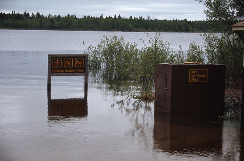
Here is one of Rob's pictures from '05 when Otter Rapids, just downstream from the photo location, was running at 690 m3/sec (down a fair bit from the peak):


Here is the same sign again in one of Bryan's pictures from a NSE family trip at the end of July in '09 when water levels were about 705 m3/sec:

For our own future reference, I've recorded some of the data from our previous 9 trips here.

Values are from data recorded at the metering station above Otter Rapids and are gleaned from the Environment Canada Water Survey Real-Time Hydrometric Data website and the Sask Watershed Authority web site. Both of these sites are very handy for trip planning. Temperatures reported are water temperatures.
  • September 3-7, 2011 - 557 m3/sec (and dropping); 17.2°C; 2.48 metres. Peak was ~Aug 19 at 2.63 meters and 612 m3/sec. (Stanley Mission - Twin/Robertson Falls)
  • September 3-9, 2010 - 336 m3/sec; 15.2°C; 1.76 metres. Peak was Aug 13 at 1.84 meters or approximately 347 m3/sec (Sandfly Lake - Missinipe)
  • September 4-7, 2009 - 590 m3/sec; 17.6°C; 2.55 metres. Peak was ~Aug 6 at 2.84 meters or approximately 730 m3/sec*. (Missinipe - Robertson Falls)
  • August 29-September 1, 2008 - 358 m3/sec; 17.2°C; 1.81 metres. Peak was June 7 at 2.27 meters or 494 m3/sec.(Barker Lake)
  • September 1-4, 2007 - 320 m3/sec; ?°C; ? metres. Peak was May 26 at 496 m3/sec. (Corner Rapids)
  • September 2-5, 2006 - 625 m3/sec; 17.1°C; 2.6 metres. Peak was Aug 16 at 713 m3/sec. (Stanley - Twin Falls)
  • June 2-5, 2005 - 690 m3/sec; 10.0°C; 2.68 metres. Peak was Aug 7 at 820 m3/sec. (Hayman Lake)
  • September 9-13, 2004 - 340 m3/sec; 1.56 m; 12.5°C. Peak was July 18 at 439 m3/sec. (Missinipe - Robertson Falls)
  • September 4-7, 2003 - 250 m3/sec. Peak was July 23 at 282 m3/sec. (Devil Lake - Corner Rapids)
  • June, 2002 - 150 m3/sec. Peak was on Oct 14 at 249 m3/sec. (Devil Lake)
  • June, 2001 - 250 m3/sec. Peak was Aug 18 at 311 m3/sec. (Stanley - Nistowiak Falls)

I've just been playing around with the graphing feature in Google Documents. The neat thing about posting the graph this way, is that I can edit the graph, change or add data and it will update here. It's not the most visually appealing bar graph I have ever made. but it works.


Mean water flow at Otter Rapids for early June and early September almost the same at approximately 310 m3/second. In June this value is on the increase (to 325 m3/sec by late June) and in September it's on the decrease (to 300 m3/sec by mid-month). The mean peaks on about July 30th with a discharge of approximately 375 m3/sec. So, the average flow is pretty steady over the summer. However, in any individual year it can peak earlier or later and change much more abruptly. Still, this gives us some values to go by in determining what is "normal" for the region we most frequently paddle.

This graph should give the current report for Otter Rapids from the Saskatchewan Watershed Authority:


Approximate location of the water metering station at Otter Rapids (you pass it on the portage):

View Larger Map

*The data provided by Environment Canada for 2009 is incomplete at the time of writing with respect to discharge values (m3/sec). Based on the water level (m) we can determine that the peak was on around August 6th, 2009. Based on that, I extrapolated the curve from those dates where values are available and arrived at a peak value of approximately 730 m3/sec. The recorded water level during this period was very uniform so I have some confidence in the extrapolated value and can be certain that the discharge level did not spike during the data gap.