Here is one of Rob's pictures from '05 when Otter Rapids, just downstream from the photo location, was running at 690 m3/sec (down a fair bit from the peak):
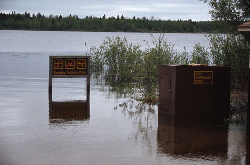
Here is the same sign again in one of Bryan's pictures from a NSE family trip at the end of July in '09 when water levels were about 705 m3/sec:

For our own future reference, I've recorded some of the data from our previous 9 trips here.
Values are from data recorded at the metering station above Otter Rapids and are gleaned from the Environment Canada Water Survey Real-Time Hydrometric Data website and the Sask Watershed Authority web site. Both of these sites are very handy for trip planning. Temperatures reported are water temperatures.
- September 3-7, 2011 - 557 m3/sec (and dropping); 17.2°C; 2.48 metres. Peak was ~Aug 19 at 2.63 meters and 612 m3/sec. (Stanley Mission - Twin/Robertson Falls)
- September 3-9, 2010 - 336 m3/sec; 15.2°C; 1.76 metres. Peak was Aug 13 at 1.84 meters or approximately 347 m3/sec (Sandfly Lake - Missinipe)
- September 4-7, 2009 - 590 m3/sec; 17.6°C; 2.55 metres. Peak was ~Aug 6 at 2.84 meters or approximately 730 m3/sec*. (Missinipe - Robertson Falls)
- August 29-September 1, 2008 - 358 m3/sec; 17.2°C; 1.81 metres. Peak was June 7 at 2.27 meters or 494 m3/sec.(Barker Lake)
- September 1-4, 2007 - 320 m3/sec; ?°C; ? metres. Peak was May 26 at 496 m3/sec. (Corner Rapids)
- September 2-5, 2006 - 625 m3/sec; 17.1°C; 2.6 metres. Peak was Aug 16 at 713 m3/sec. (Stanley - Twin Falls)
- June 2-5, 2005 - 690 m3/sec; 10.0°C; 2.68 metres. Peak was Aug 7 at 820 m3/sec. (Hayman Lake)
- September 9-13, 2004 - 340 m3/sec; 1.56 m; 12.5°C. Peak was July 18 at 439 m3/sec. (Missinipe - Robertson Falls)
- September 4-7, 2003 - 250 m3/sec. Peak was July 23 at 282 m3/sec. (Devil Lake - Corner Rapids)
- June, 2002 - 150 m3/sec. Peak was on Oct 14 at 249 m3/sec. (Devil Lake)
- June, 2001 - 250 m3/sec. Peak was Aug 18 at 311 m3/sec. (Stanley - Nistowiak Falls)
I've just been playing around with the graphing feature in Google Documents. The neat thing about posting the graph this way, is that I can edit the graph, change or add data and it will update here. It's not the most visually appealing bar graph I have ever made. but it works.
Mean water flow at Otter Rapids for early June and early September almost the same at approximately 310 m3/second. In June this value is on the increase (to 325 m3/sec by late June) and in September it's on the decrease (to 300 m3/sec by mid-month). The mean peaks on about July 30th with a discharge of approximately 375 m3/sec. So, the average flow is pretty steady over the summer. However, in any individual year it can peak earlier or later and change much more abruptly. Still, this gives us some values to go by in determining what is "normal" for the region we most frequently paddle.
This graph should give the current report for Otter Rapids from the Saskatchewan Watershed Authority:

Approximate location of the water metering station at Otter Rapids (you pass it on the portage):
View Larger Map
*The data provided by Environment Canada for 2009 is incomplete at the time of writing with respect to discharge values (m3/sec). Based on the water level (m) we can determine that the peak was on around August 6th, 2009. Based on that, I extrapolated the curve from those dates where values are available and arrived at a peak value of approximately 730 m3/sec. The recorded water level during this period was very uniform so I have some confidence in the extrapolated value and can be certain that the discharge level did not spike during the data gap.

No comments:
Post a Comment